Rivers Initiative Spotlight: The Narraguagus
Eleven years of conservation efforts in this Downeast watershed have strengthened its health and long-term resilience
As alewives and other sea-run fish migrate up the mouths of Maine rivers this spring, MCHT is celebrating the outsized impact these aquatic habitats have on the health and resilience of coastal ecosystems. For more than a decade, we have worked with partners across the state to carry out our Rivers Initiative, a collaborative effort to protect and restore five key rivers along Maine’s coast that provide passage to sea-run fish and support wildlife and human communities in countless other ways. These aquatic habitats will become ever more important landscape connectors in a warming world, which is why we remain committed to their wellbeing now and in the future.
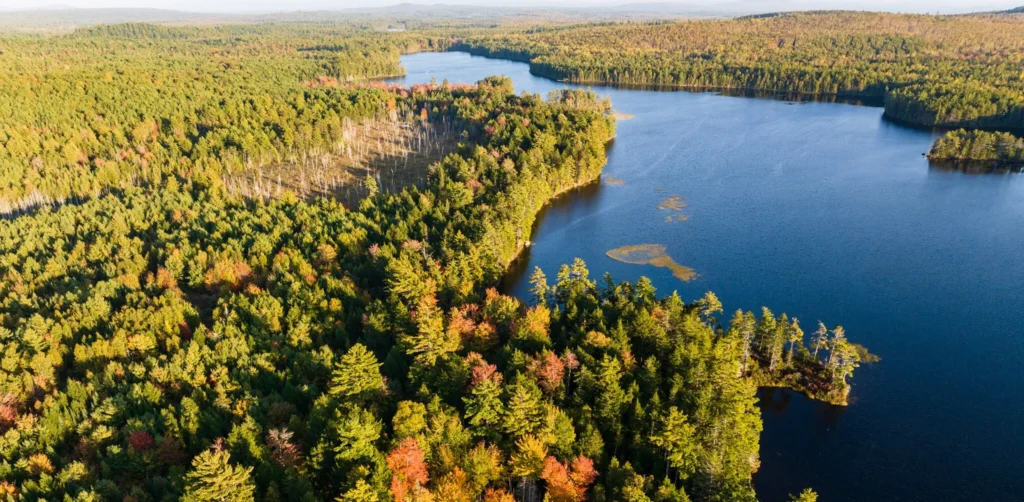
The Narraguagus River, located in Downeast Maine, has seen great progress in restoration efforts since becoming a focus area of the Rivers Initiative in 2014. Running for 55 miles from Eagle Lake in Hancock County down into the Narraguagus Bay in Milbridge, this river flows with some of the cleanest and healthiest waters on the Eastern Seaboard. It has long provided spawning grounds for sea-run fish including alewives, shad, brook trout, and Atlantic salmon, and these fish have long been central to the local culture, ecosystem, and economy.

While this river and its watershed remain healthy by many measures today, centuries of human activity and development along its banks have taken a toll. Over the past eleven years, MCHT has worked closely with partners in the region to help increase connectivity within the channel, expand riparian buffers, and bring the river back to its natural form. In collaboration with the Downeast Salmon Federation, The Nature Conservancy, the Atlantic Salmon Federation, and the Forest Society of Maine, we have collectively completed a total of 18 projects in and around the watershed that have amounted to 16,024 acres and 30.7 miles of river frontage protected. MCHT does not hold any land in this watershed, but instead has supported the purchase of lands by our partners.
Recent project highlights include the protection of 3.2 miles of shoreline along the river’s headwaters on Eagle Lake in partnership with the Forest Society of Maine, and the protection of a 2,900-acre parcel along the river’s west branch in partnership with The Nature Conservancy. This new parcel, called the Spring River Narraguagus Addition, includes 12.5 miles of frontage and abuts existing conservation land that amounts to more than 45,000 acres of contiguously protected undeveloped habitat. This type of landscape-scale conservation has become a priority of MCHT in recent years as climate change forces species to migrate and adapt to a warming world.
To support the passage of sea-run fish up into inland waters, MCHT has helped spearhead plans to remove the Ice Control Dam in Cherryfield that has blocked migration since its construction in 1961. Based on a five-year study conducted by the Army Corps of Engineers, the Town of Cherryfield voted to remove the dam in 2023 and replace it with a nature-like fishway—a project funded by a $9.1 million grant from the National Oceanic and Atmospheric Administration that was secured by project partner the Downeast Salmon Federation and includes the improvements to a riverside public park. The project will break ground next spring.

“We have made real breakthroughs in the past couple of years,” says Jacob van de Sande, Associate Director of Land Protection at MCHT, who has worked on restoration efforts along the Narraguagus in different capacities for three decades. “It is a great example of how the Rivers Initiative has built over time, and how this work takes a long time to unfold. These are not two-year plans or five-year plans, these are ten, twenty, thirty-year plans to achieve the kinds of goals we are seeking.”
Meanwhile, MCHT continues to expand public access elsewhere along the river in collaboration with the Downeast Salmon Federation, which has been a partner on 15 of the 18 projects carried out within this watershed. Together with DSF, we have preserved 8.5 miles of shore frontage across 1,328 acres—including a 150-acre parcel above Little Falls on the Narraguagus River that DSF purchased in May. Beyond expanding community access to the river, riparian buffers like these also help filter storm runoff and provide cool havens for vulnerable species including endangered wood turtles, wood ducks, black ducks, and a variety of mammals.
Our coordinated efforts in this region will support all of the species that find a home in this watershed—from the sea-run fish returning this month, to the birds of prey who may feed on those fish, to the flowers that may bloom from the bird’s droppings, to all the other species that find a home in or around these waters. A coastal habitat is only as healthy as the freshwater arteries that bring that habitat to life.